
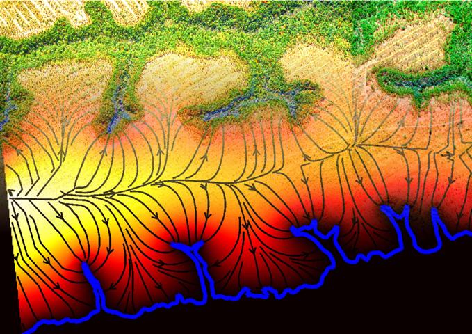
Seepage channel networksRiver networks appear when small tributaries meet to form creeks, which combine to form larger streams, and so on up to the scale of major rivers. In typical networks, the water originates from rainwater or melting ice, and follows the path of least resistance as it flows over the surface of the ground. This overland flow, and the erosion it causes, has been a popular subject of study for some time. Seepage channel networks, though similar, have a different origin. The water in a seepage channel originates at a spring, where groundwater seeps through the soil to emerge at the surface. In the process, the water carries with it a small amount of sediment, causing the spring to slowly move over the course of many years. Surprisingly, a set of simple linear growth laws can accurately predict the movement of springs (the "fingertips") and the large-scale channel structure in a seepage-driven network. This is remarkable because it means that the physical environment over regions tens of kilometers in size can be determined by simple growth laws, rather than unpredictable subsurface heterogeneity. For more information, please see "Growth laws for channel networks." The shape of growing valleysValleys can be carved by a range of geophysical processes. Often, the valley "heads" show an intriguing amphitheatre-shaped structure. With the mild assumption of curvature-driven growth dynamics (i.e., rate of erosion proportional to curvature of the valley lip), our theory makes the remarkable prediction that valley head shapes should have an aspect ratio of pi. In fact, this prediction seems to be correct for a large set of valleys varying in size from centimeters to hundreds of kilometers, and not just on Earth! Mars channel networks also seem to show this aspect ratio, perhaps hinting at the process through which they formed. For more information, please see "Geometry of valley growth." Historical climate oscillationsDuring the past million years, the earth's climate has regularly oscillated between cold and hot phases, known as "ice ages" and "interglacials." Ice ages have recurred on a fairly regular schedule, usually about every 100,000 years. The most widely accepted explanation for this oscillation proposes that very long period oscillations in the earth's orbit cause changes in the amount of heat reaching the earth from the sun. This explanation can also account for another strong climate signals with a period of 41,000 years. Unfortunately, there remains a disconnect between our understanding of orbital mechanics, and our understanding of the global climate on earth. Perhaps better analytical models of the key elements in earth's climate system will allow that connection to be made, reinforcing our confidence in our understanding of climate. Statistical topographyWhat causes hills and valleys? This seemingly basic question has many answers. The theory of plate tectonics, invoking subduction and uplift, gives the most common explanation. Glacial action may also have played a role in many world regions. However, even in regions that have a long history of little tectonic activity, we find varying topography. Taking the florida panhandle as an example, we find low-relief hills and troughs at almost all spatial scales throughout the region. Understanding their origin may have more to do with stochastic differential equations than traditional tools of gromorphology. |
| Danny Abrams | 847-491-5346 | Office M444, Technological Institute, Northwestern University |